
 This blog describes the second of two exciting mountain drives to and fro across the Andes of Southern Peru, taking in two of the deepest canyons in the world, Colca and Cotahuasi. This drive took us from the historic city of Arequipa, through the remote Cotahuasi canyon and over one of our highest passes yet, to join the major road to Ayacucho, arriving just in time for the start of its carnaval on 6th February.
Rebecca here…

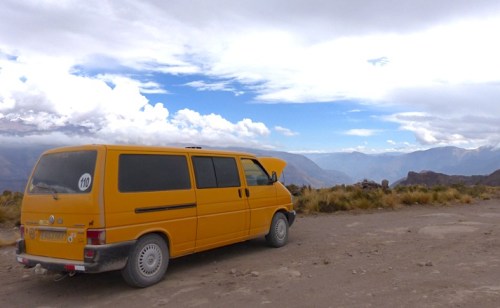
The joys of the traffic on the PanAmerican Highway outside Arequipa
While we were in Arequipa, we realised Carnaval season was coming up and, having missed it while we were in Patagonia last year, we decided to try to see some celebrations. A little googling later, we learnt that Ayachucho was meant to do a good Carnaval in Peru and this year (2016), it would kick off on Saturday 6th February, which gave us a week to get there. But Ayachucho was back up in the mountains again, when we had expected to stick to the coast of Peru for the next part of our journey north, given it was still the rainy season.

But with the pleasure of lovely new tarmac and freshly painted lines!
We peered at the map and realised that the most direct route would take us through the much less visited Cotahuasi canyon, a deeper canyon than Colca, which we had recently visited (see accompanying blog here). This route would also be a much more interesting drive than simply going north up the Panamerican highway along the coast then inland from there on the main road to the city.
However, we couldn’t determine for sure that there was a driveable road up and out the other side of the canyon to continue on up and across the mountains and on to the main road to Ayacucho from there, as the maps (digital and paper) showed just the smallest of lines and didn’t agree on where those lines went! And whether the Yellow Van would be good for the drive from there was also a question – would the road out of the canyon be too steep? Or at too high an altitude? Or both? We had no way to be sure, but reassured by the few waymarks and camping spots shared by other overlanders on iOverlander.com, we decided we’d go have a look and try to get some local advice when we got to Cotahuasi itself, the town in the canyon.

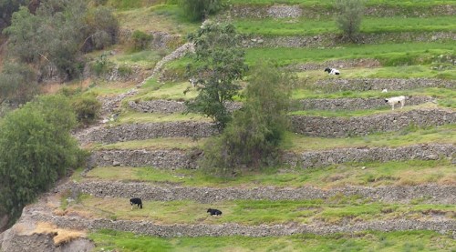
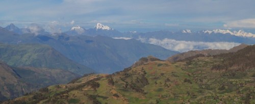
The Pacific side of the Andes in Peru is mountainous desert punctuated by lush valleys fed by water coming down from the mountains, all covered in a thick haze much of the time
To Cotahuasi Canyon and beyond…
Marginally deeper that Colca canyon, Cotahuasi is less visited because it is much harder to get to. Where a good surfaced road covers the few hour drive from Arequipa to the entrance to the Colca canyon, Cotahuasi canyon is considerably further to drive (even the way Peruvian bus drivers drive) and much of the road is unfinished.
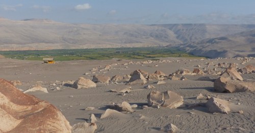
Parked next to the boulder field of the Petroglifos de Toro Muertes
Our first stop on route was at the Petroglifos de Toro Muertes, a large boulder field (spewed out by a volcano apparently) above the village of Corire on which many of the boulders have petroglyphs thought to have been drawn by the pre-Incan Huari people. They are well scattered and not as dense in number as we expected, but some are quite large and well preserved.


The parking area had a shelter that we backed under to help conceal us for the night. It was the lowest we’d been for awhile, down at around 275m and it was warm! It felt rather odd to be warm all night after so long at high altitudes.
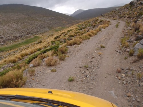
As we continued up the valley the next day, first the finished surface ran out, then the road got smaller and rougher. In true form, we decided to try to have the best of both worlds and, at a fork in the road, the left fork being the direct route to Cotahuasi, we decided to take the right fork towards the “valley of the volcanos”, to have a look in that direction, before cutting back across on a small road behind Volcan Coropuna, to rejoin the road to Cotahuasi. That may have been a mistake!

 The tiny road skirted the hillside and climbed up the valley.
 Emerging into a rich valley at the foot of the volcano.
 Our route back across to the main Cotahuasi road weeved steeply up to a pass between the volcanos. There may have been beautiful views if the whole valley had we not climbed into the cloudline, rendering this little detour a little pointless (for seeing volcanos)!

Following some donkeys up to the pass

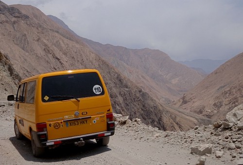
Considering our options after the tyre blow-out
Partway up, we suffered a dramatic tyre blow out – our worst yet and the second in a few weeks. Perhaps it was time to get new tyres. With the already patched spare put on, we contemplated our options. We didn’t want to continue on this long, remote drive as planned without a functioning spare tyre and we weren’t sure whether we’d be able to get it fixed, as it was a pretty big blow-out. But if we went back and took the PanAmerican highway up the coast instead, it would still be several days tedious drive to get to Ayacucho for Carnaval. We decided to carry on to Cotahuasi and see if there was someone there able to repair the tyre and we would try to buy some new ones in Ayacucho if and when we got there.
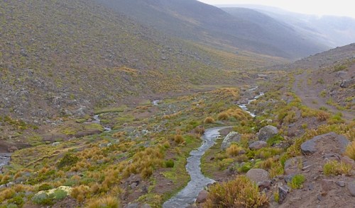 It may have been a rather pointless detour, but it was rather beautiful crossing the high puno on what was little more than a track. In many spots, there had clearly been some earth slides, probably in the recent rains, and we were just following the trails of previous vehicles and maybe a small grader than had simply driven over the new piles of earth to make a new, rough track.
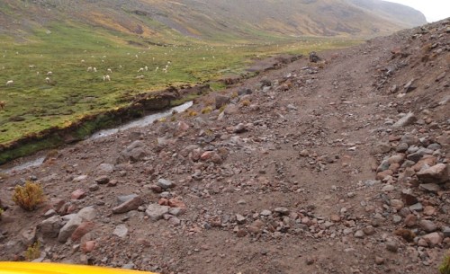
Following the rought tracks of previous vehicles across freshly slipped earth

The Yellow Van coped admirably!
We could really have done with a little more clearance for this section of drive, but going slowly and carefully, we only caught the underside slightly once or twice, with no harm done.
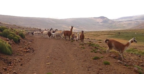
Out of the way guys – Yellow Van coming through!
The head of the valley opened out into colourful, dry high level puna.


A tribute to workers in this tough, inhospitable terrain
We got into Cotahuasi just as it was getting dark and were pleased to find a little hospadaje with secure parking (i.e. behind a locked gate) for the night.

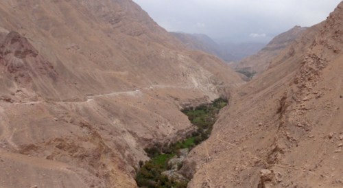
Looking down into the Cotahuasi canyon from the road above

Waiting to have the blown tyre repaired
Next morning, we started out early to find a tyre repair shop and were pleased that they seemed quite happy that our blown tyre was repairable, despite the rips to the side-wall as well as a cut to the tread itself. We had to wait a little, as the guy was working on a truck tyre when we arrived, so we put the kettle on and made a cup of coffee while we waited, to the interest of the local folk walking past heading in for school and work! After watching them repair it, we decided it would be good enough to rely on as a spare for the rest of the planned drive.
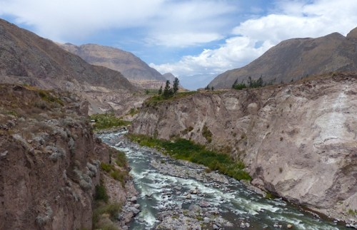
Beautiful, unspoilt Cotahuasi canyon
We asked to the guys at the tyre shop about the best route onwards. They recommended the road climbing straight out the otherside of the canyon and crossing the puno above that, rather than following the road up the canyon, as we had expected to do. It was a much better road, they explained. We got a second opinion to that effect from the tourist office, so that was the way we went.
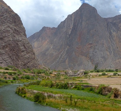
The lush valley at the bottom of the canyon
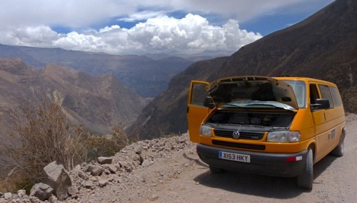
It was a long, steep haul up and out of the canyon, following the line of a side valley climbing up the side along repeated series of switchbacks.


The road out of the Canyon snaking up a side valley, climbing 1,600m to the edge
But the Yellow Van did well, only overheating once we topped out onto the surrounding puna above. We sat and had a bite of lunch while the van had a rest, with a condor sweeping around us.
Giving the van a cooling off rest part way up
It didn’t overheat until we got over the top
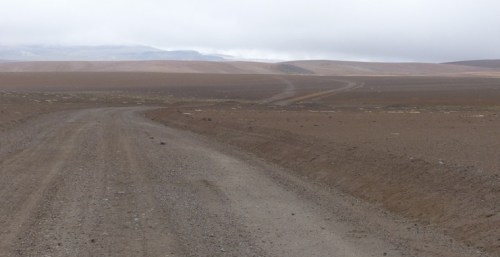
From there, our route took us on a long trail across the high puna, climbing steadily upwards and onto more and more remote and desolate terrain.


 We left the herds of alpacas and llamas behind for a little and enjoyed seeing a few untamed vicuña again.


The view at our highest altitude to date
On the top of the puna, we reached our highest altitude yet at 5,129m, which, unfortunately, but perhaps not unsurprisingly given the time of year, was above the cloud line.

The GPS reading 5,129m
Up at these heights, we battled with a loss of power to the engine and, more than once, found ourselves shouting encouragement to the van to make it up and over the top of next rise in the road. The turbo seemed to be not kicking in reliably – once it did, there was no shortage of power, but sometimes it didn’t kick in and we really felt a loss of momentum as we climbed each rise, creating some heart in mouth moments. What would we do if we couldn’t get over these hills? Turning around just meant going back over the ones we had already come up!

The was the occasional traffic – two large lorries in the distance going the other way

It was miserable, cold and grey up there – but pretty exciting nonetheless!
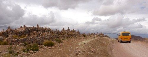
On the otherside of the valley, we reached what must be considered to be the edge of the pass, where it looks out towards the valley between the lines of mountains. The edge of the road was decorated with piles of stones (“cairns to us Brits”) that mark the passes in the Andes.
 We spent that night up there, pulled into a pull off behind a pile of rocks left by the road builders, at the foot of line of volcano cones. It was cold, but we stayed snug under our down sleeping bags and little collection blankets.
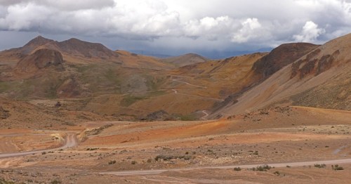
Late morning the next day, with some relief, we emerged onto the main, tarmaced road from the coast up to Abancay. We briefly considered cutting a corner across from there to the main route 3 road from Cusco to Ayacucho, but we had now crossed into the wet side of the mountains and, faced with one of those little road clinging to the steep valley side, but this time wet, muddy and slippery, we retraced our steps and took the longer, but safer, route on well maintained, fully surfaced road!

We drew a line at this – the slippery mud makes all the difference!
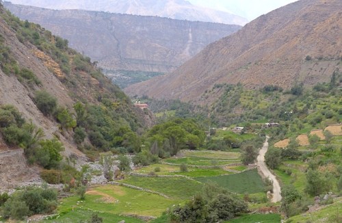
After a night in a rather cute little campsite, where we parked under an avocado tree and the pet sheep in the house (yes, sheep) kept pawing at Bruce’s shin when he went inside to pay, we popped out onto the route 3, Peru’s main road up through the mountains. This was just on the other side of the range above Machu Picchu and Choquequirao – almost a full circle of exciting mountains and canyons!
View from the route 3 – we think the largest peak is Salcantay above Machu Picchu
It was another couple of days drive up the route 3 from there to Ayacucho, with the road repeatedly descending into valleys and climbing up out and over another spectacular pass into the next valley. Aware of the need to careful of security in these parts, we spent the night in a small hostel with parking in Chincheros. As we pulled into the carpark of our hotel a short walk from the centre of Ayacucho, we found there were 3 tyre shops right next door! Couldn’t be more convenient and a new pair of tyres were put on the front wheels, with the best of the rest rotated around and demoted to spare appropriately.


Carnaval in Ayachucho
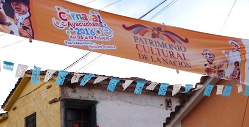 We arrived in Ayacucho on Friday afternoon (5th February 2016), with the four day Carnaval due to kick off the following day. The proprietor of our hotel furnished us with a leaflet and showed us on a map the route nearest the hotel that the procession would take. As it turned out, there are several “routes” of closed roads along which the numerous groups gather and wait their turn to enter the main square, which is the focus of the procession.

Balconies decorated around Ayachucho’s main square
Ayacucho has a lovely colonial central square and, when we arrived late Friday afternoon, we found the balconies around it tastefully decorated and stands of seating being put up. Sat in a bar on one of those balconies, we were excited by a little preview of one group rehearsing their march ready for the next day. So, on Saturday morning, we excitedly headed along one of these routes to the main square, where the procession was due to kick-off around midday. The huge numbers of groups and people in colourful, albeit similiar costumes, was a spectacular start!

Colourful groups gathered on the roads leading to the square
However, on the whole, it turned out to be a little bit of a mixed experience in the end. After the initial procession with the Carnaval queen at the head, most of the numerous groups of women dancing in traditional dress accompanied by men playing instruments and banging drums, were almost identical, just varying in colour scheme. They even all sang and played the same tune! This was fun to start with, but the novelty began to wear off after awhile! Once we’d established that it was more of exactly the same on day 2, the Sunday, we really had had enough – and there was going to be another 2 days of it! It seems that groups representing all different types of organisations, from schools, sports teams, to companies and industry groups, all converge on Ayacucho from around the whole region, all dressed up in the same traditional manner with the same song prepared (although some tweak the quechan and spanish lyrics a little), then each have their moment at some point over the 4 days when they parade through the square.
 Nevertheless, it was a wonderfully happy and colourful event that we were really pleased to have made the effort to see in person:


Pingback: Canyon & Convent: Adventurous driving in Peru part 1 | Yellow Van Days
Great post and happy to find that our favourite Yellow Van crew are still rolling! We might bump into you next year in the USA if you’re still driving north as our rig will be heading that way in Spring ’17. Also recommend you look out for John & Suzanne http://www.tiggers-travels.com from Cambridge who went East across all the Stans then through China & East Asia in their VW Syncro Camper soon on their way over from Malaysia to probably drive down the Pan-Am. Keep healthy and safe travels you two Amigos ~ D&Mx
LikeLike
Pingback: Peru’s historical coast: A journey through time | Yellow Van Days