

The sarcophagi of Karajilla
[June 2016] After May’s events, June could only be an improvement. With the van running well after all the repairs, but nervous as to how long that would last, we nevertheless decided to stick with our plan to drive north to the border with Ecuador through the mountains of Peru and we are very glad we did… It was a spectacular few weeks, taking us along dramatic roads between historical towns and through the beautiful landscapes of the romantic Cloud People. A few days into the drive, we got news of the birth of my little niece – a little bundle of joy to cheer up June! This blog is a picture story of this wonderful journey.
Rebecca here…

June was indeed an improvement. After our extended stay in Huaraz waiting on the mechanical work, then a little test drive around the beautiful Cordillera Blanca,on Saturday 4th June, we set off north towards the Ecuadorian border. We were ever mindful of our impending deadline for leaving the country (we had until 23rd June and Peruvian customs are known for being strict about this, supposedly having the option of seizing a vehicle that has overstayed!), but this gave us 3 weeks to enjoy one of our most spectacular drives yet.


As we travelled northwards, we trended eastwards and the landscape became greener and more lush.


Bruce improvising something with wire to hold the resistor controlling one of the radiator fans in place
We took it gently, giving the engine regular rests to cool down when we were climbing steeply (typically, about 50% of the time!) and monitoring the temperature with the computer. We hadn’t been going long when we lost one of the resistors controlling the radiator fans – the housing to hold it in place was shot and the cable ties put there instead melted! We improvised with some wire, but that ended up damaging the resistor permanently. But, with frequent rests, the water cooling system was up to the job on its own.

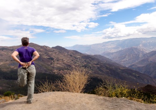
Using our regular engine rest breaks to do a little stretching whilst enjoying the view!
A few days into the journey, as we rolled into a tiny little remote mountain village one afternoon with just enough mobile data service to check emails, I got news that my sister had given birth to a baby girl, my new niece. The locals, who were already wondering about the strange foreign yellow van that had stopped in the road during one quiet, Sunday afternoon of drinking, thought we were even stranger as I leapt out of the van and did a little dance of joy in the middle of the empty road!
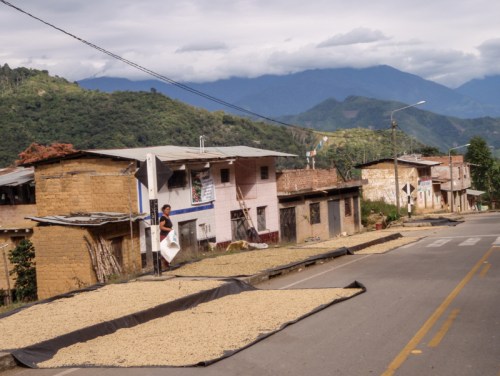
 We stayed in the mountains, which, given the geography Peru, with ridges of mountains and valleys lying perpendicular to the coast, meant going up and down across numerous lines of mountains, making it both dramatic and very slow going. A few kms of distance “as the crow flies”, frequently required 10s of kms of switchback driving down into a valley and up the other side, taking half a day on the road.
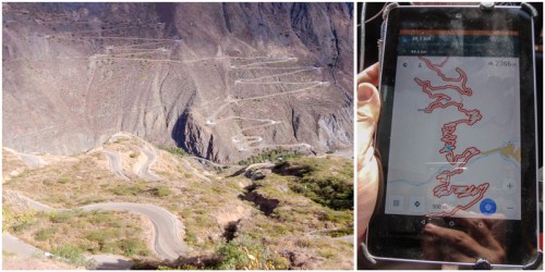
Many kms of switchbacks down and back out of a valley in order to travel just a few kms in a straight line on the map!

Some of the roads had asphalt and were in pretty good condition, but the geography and climate is hard on them too – this sort of thing is why we don’t like to drive after dark!
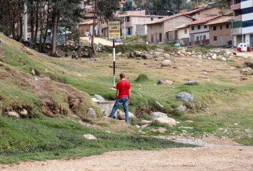
Filling up our (non-potable) jerry at a public water pump by the road (washing of vehicles prohibited!)

Artist’s impression of the funeral (?) towers of Marcahuamachuco
On the way to Cajamarca, our first major destination, we detoured to see the ruins of Marcahuamachuco. This pre-Incan site (constructed in AD 400 onwards) is believed to be Northern Peru’s most important economic and political centre before the invasion of the Incas.

The extensive pre-Incan ruins of Marcahuamachuco
The rainy season might, in theory, have been over, but that didn’t preclude the occasional phenomenal downpour turning the road into a river.


But sun and rain is the recipe for a beautiful rainbow…
 Camped behind a little restaurant next to Laguna Sausacocha, with newly acquired sours and martini, we perfected our new favourite cocktail – pisco martini.


The city of Cajamarca was the location of the infamous events that lead to the Spanish pretty much walking into and taking over the extensive Incan empire. The Incan leader Atalhualpa (fresh from the defeat of his brother in a civil war) invited the Spanish conquistador Pizarro with his small army to a meeting, expecting, as was Incan custom, to have talks.

Atalhaulpa indicates that he will fill the room to the level of his reach with gold and silver
Supposedly excused by Atalhualpa’s rejection of the gift of a bible by a priest travelling with Pizarro (obviously, he couldn’t understand it and it was of no relevance to him), the Spanish surprised the Incans by seizing Atalhualpa and taking him hostage. Remarkably, although the Spanish colonists completely rebuilt the city, the building that Atalhualpa was imprisoned in has been preserved, rather strangely behind the facade of a typical Colonial building. Legend has it that a ransom of gold and silver sufficient to fill the room to the level of Atalhualpa’s reach was agreed and the supposed line is marked on the wall. After the ransom was paid, the Spanish executed Atalhualpa anyway.

The “ransom room” preserved and hidden behind the facade of a colonial building in an otherwise normal appearing colonial block in Cajamarca


Cajamarca today is a rather pleasant historical colonial city and we enjoyed a day wandering the streets, looking in churches and little museums, before heading out of town to enjoy a private bath in the nearby hot spring baths – supposedly where the Incan king himself bathed! Here’s a little gallery of images of Cajamarca:


Also just outside of Cajamarca are the Ventillas de Otuzo, little funeral chambers carved into a sandstone cliff, where pre-Incan cultures used to put the remains of their dead.


This was our first glimpse of the Cloud People culture that we were to encounter in the Chachapoyas valley, our next destination…

Camped at a little hacienda just outside of Cajamarca, we met this crazy tiny little rat dog. After making friends with us, it ran off with one of Bruce’s flip-flops – luckily I spotted it as it was disappearing round the corner…

The church at Pollac
A short drive north-eastwards is a remarkable church on the edge of the village of Pollac. It is a large complex decorated inside and out with beautiful mosaics of religious imagery. It was quite strange to find this on the edge of a remote, otherwise quite typical, little mountain village and we haven’t been able to find any information about what the story behind it is. Unfortunately, they wouldn’t let me take pictures inside, but the ones from the outside are beautiful enough!


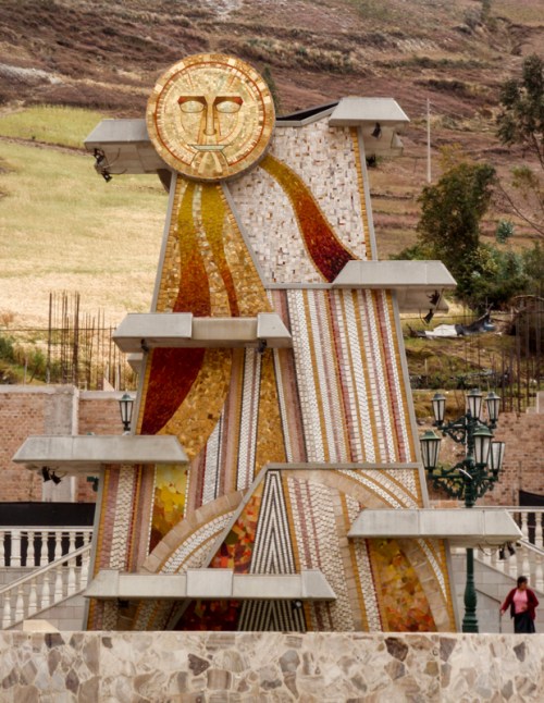
Further up the road, the village squares each had impressive statues, like this one celebrating the sun, also on the mosaic theme:
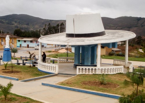
 And this one celebrating the local style of hat!
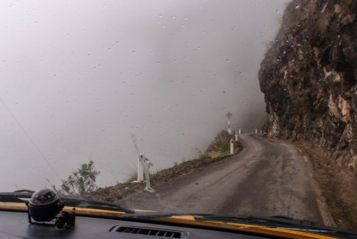
 The next couple of days driving up and over the mountains into the Chachapoyas valley was breath-taking and sometimes positively hair-raising.


 The region of the Chacapoyas, the Cloud People, in the cloud forests of the eastern Andes, was a magical trip back in time. Although there is evidence of much earlier settlement in the area, the Chachapoyas culture emerged in strength around 700-800AD (although construction of the city of Kuelap started in the 6th century) and lasted until they were subdued by the Incas in 1475. The 500,000 or so population capitalized on their ability to control the trade routes between the cultures of the Amazon and Andes.
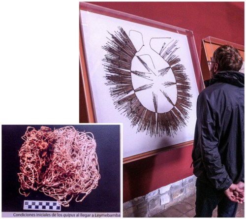
A quipu found in the Chachapoyas region. This is the only form of writing known to exist in pre-Colombian South America and yet to be deciphered. The inset photo shows what it looked like when it was found – that’s quite a bit of untangling!

Some of the mummies stored in a laboratory within the museum
Our first stop in the valley was the museum at Leymebamba, which was built by the local people to house around 200 mummies found in burial chambers high in the cliffs above the nearby Laguna de los Condors. It is a beautifully done museum with lots of information providing a great introduction to the area.

Looking out from the man-made plateau of the city of Kuelap
The Chachapoyas was a strongly egalitarian society, which is evidenced in the architecture of Kuelap, the main centre. All but a few ceremonial buildings in this long hidden-city are round houses of the same size and shape.
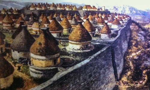
Artist’s impression of the egalitarian Chachapoyas city of Kuelap
 Kuelap, dubbed the Machu-Picchu of the north, was built high up above the valleys on a walled plateau, concealed for 100s of years until rediscovered in 1843. It is a magical place to walk around, starting with the secure narrow entrances talking you up through the walls onto the city plateau above. And it is free of the crowds of the Incan ruins to the south, but they are building a cable car to make access easier, so that may change soon…


Another thing we were really keen to see in the Chachapoyas area was one of the sarcophagi sites. This required another dramatic drive up into the hills above the main valley:
 At Karajilla, you can see where the Chachapoyas put their dead in striking looking sarcophagi stood at the entrance to caverns within the cliffs high up above the valley. In this and a few other places, the sarcophagi are still standing:

The sarcophagi of Karajilla
It was a steep walk down to follow a trail along the cliff face to get to see them, stood in state high above the valley.


We parked in the square of the village above the cliff and the villagers were happy to let us spend the night there (admittedly at rather a steeper angle than ideal, but we arranged it so we slept head-up!), even leaving us with the key to the public toilet overnight.

The village square
After a stop in the also charming colonial town of Chachapoyas for the night…


…we continued northwards, deciding we had time for a detour to see what is touted locally (but disputed internationally) as the 3rd highest waterfall in the world.
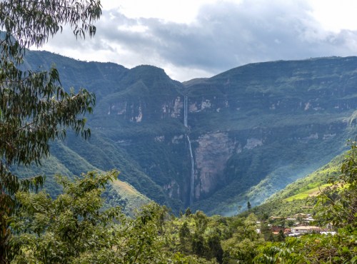
The Gocta falls in the distance – unfortunately north facing and always in the shadow!
It was pretty enough and an enjoyable walk:


But the highlight that made it so worthwhile for us was happening across a pair of iconic cock-of-the-rock birds.
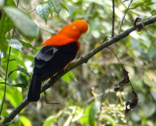
An elusive but delightful looking Cock-of-the-rock
These crazy looking birds are famous for, well, looking a little crazy. Even the camera seems to find them confusing and struggled to focus on them – where is the “edge” exactly, and where is the beak?


The journey to the border took us back west into the dry side of the Andes

Camped by a river with a hot spring bath-house on its banks! Very convenient for grubby travellers…

Nothing in the van for you little goat!
And, surprisingly, through some valleys filled with rice paddies


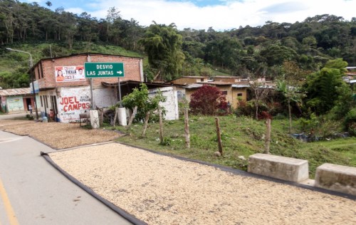
Before we climbed up into the Andes again and through coffee growing regions, where we found the roads lined with drying coffee “cherries” (the beans themselves are inside the fruit).
With some relief, on 17th June 2016, we crossed the border into Ecuador with a few days to spare on our visas and van permit. We crossed at a remote and little used border crossing in the mountains, which made the entry process on the Ecuador side rather slow. Ecuadorian customs is digitised and everything must be entered into the computer system for a code to be issued for the temporary import permit. This poses a problem when the customs office at the border has no internet connection!

Just me and the chicken in the customs office at the remote Ecuadorian border crossing
When Bruce went with the customs office to use the phone in the police station next door to do this by telephone (shouting all the details, letter by letter, number by number down the line – this took awhile), a chicken wandered into his office and took up residence on the, presumably warm, powerpack for his computer. As the officer returned, the chicken got up and wandered out again – it looked like it had done this before!!
The van had performed well, but we were starting to be concerned about squidgy steering… but that’s a story for the Ecuador blogs!

This important matter of stocking up on Pisco before crossing the border

Pingback: A Miserable May in the Cordillera Blanca, Peru | Yellow Van Days
Way cool. Thanks!
LikeLike