
 Our route north to Santiago de Chile took us on a zig-zag, to and fro across the Andes, travelling, mostly, up the beautiful, lush and verdant, western Chilean side, whilst also crossing back to the east, to take in the highlights of the Argentinian side of the Andes on the way. To give some geographic continuity, this blog recounts these Argentinian treats, while the following, accompanying blog (part 2: Southern Chile) describes the two legs of the journey north through southern Chile.Rebecca reporting…
Each of our four Argentinian treats described here has small gallery of photos at the end, which can be opened for separate viewing, but keep scrolling down to see all four delights!
Argentinian Treat 1: The Cave of Hands
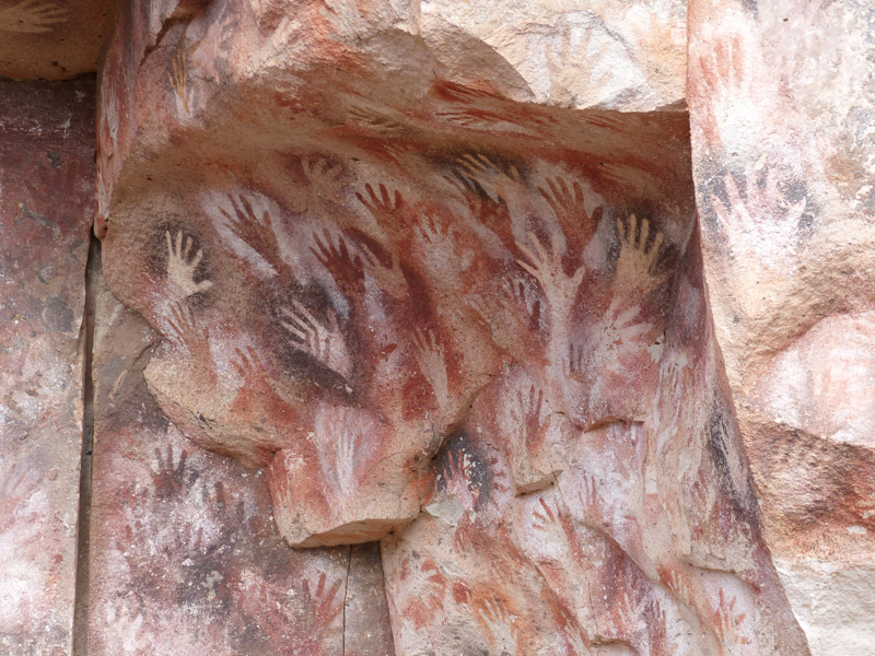
Beautiful 9,000 year old hand paintings
On leaving the Parque Nacional Los Glaciares, the journey north started with long, dry, straight “ripio” (gravel) roads, following Argentina’s famous “Ruta 40”. This is the most remote road that we have driven on so far and our target was the UNESCO heritage site of “The cave of hands”, in the desert south of the town of Perito Moreno. There are numerous caves in Patagonia that were populated by original settlers in the region, around 9-10,000 years ago, that have some cave paintings (we visited another in Southern Chile), but this one is one of, if not the, most extensive and well preserved.
It’s partly the geography that is a surprise here – the region appears to be flat, dry desert, then from nowhere, you find you are peering down into a dramatic canyon with a river at the bottom and lush vegetation. You can quite see why early nomadic peoples would have found caves in the sides of these canyons, with good sight of prey animals moving along the river below and safe places to base themselves. Of course, no one really knows why they painted their hands on the walls, using various techniques and over different time periods, whether it was for ritual, communication or for fun. The different colours used reveal access or trade in minerals across a wide distance.
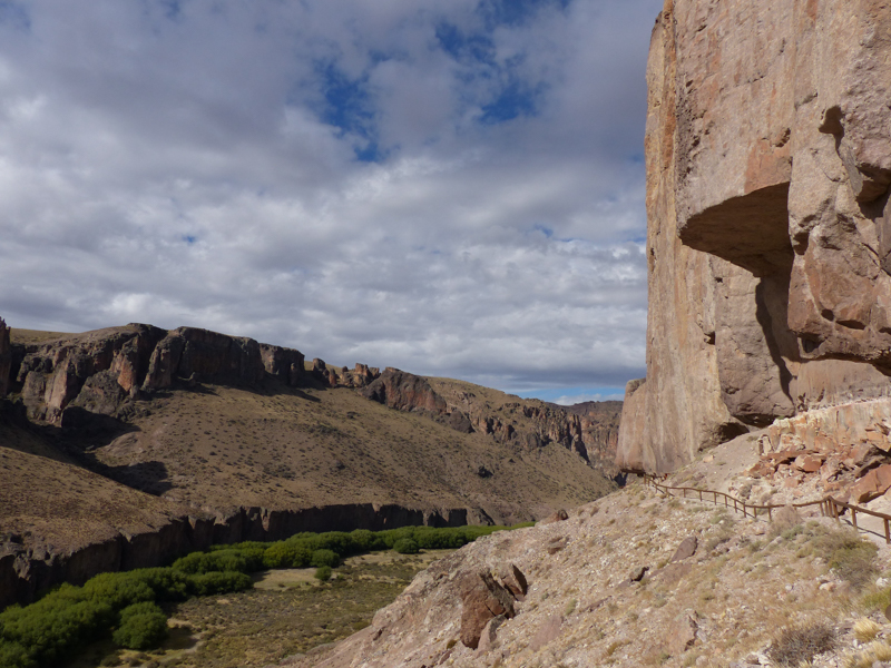
The dramatic canyon setting for the cave
Unfortunately, these caves are now behind a wire fence for protection, but this does not detract from the sense of history, nor does the gentle stream of visitors driving long distances to appreciate what went before. Arriving towards the end of a hot day, we were hoping to find a quiet spot to free camp nearby and, when a guide heard us quietly admitting that to some student hitch-hikers to explain that we couldn’t give them a lift out that evening, the guide volunteered that people in campervans often parked in a pull off about half way up the road out of the canyon. We might not have done so, had he not said that, as this little spot, with just room for one vehicle, was in full view of the visitor’s centre, but there was no more traffic until the first visitors the next day and it gave us a splendid view over the canyon for the night.


From here, we headed west and across the border into Chile, following the southern side of Lago Buenos Aires (or Lago General Carrera at the Chilean end), the largest lake in the south. This is the furthest south that you can cross by a road to pick-up the Carretera Austral, Chile’s road to the far south. The next section, driving the up the Carretera Austral, is described in the Chilean blog post (part 2: Southern Chile).
We returned to Argentina a few weeks later, with a target to get to Bariloche and the Cerro Catedral mountain range before the end of March and the start of autumn in April when the weather starts to deteriorate and becomes less predictable. We wanted to enjoy the climbing and trekking there while it was still summer.
Argentinian Treat 2: Piedra de Parada
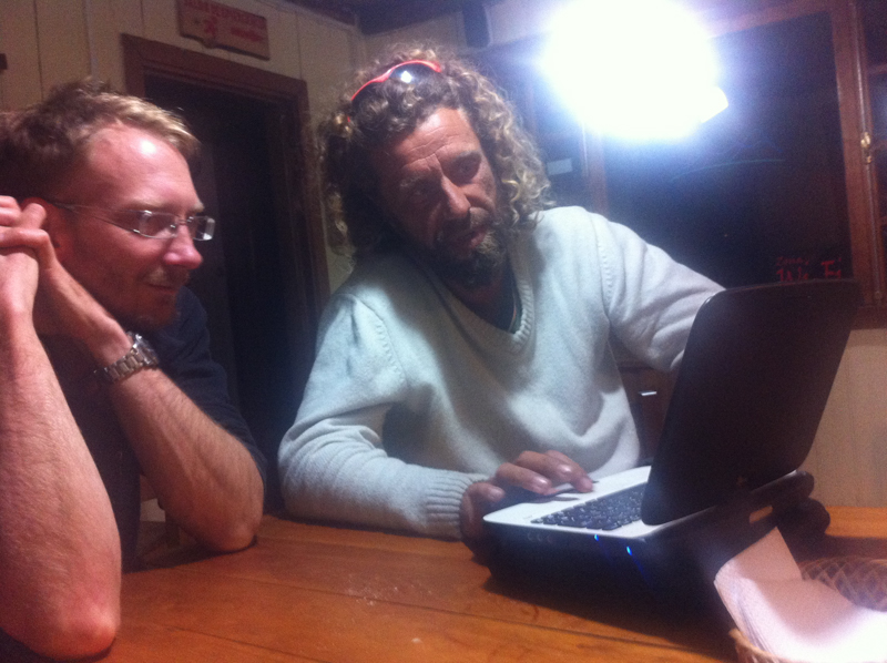
Bruce and Romain consider the next day’s weather forecast
Just before crossing the border back into Argentina, we ran into our cyclist friend, Romain, who we had first met in Montevideo, in Bruce’s class at the lauguage school. We had seen him briefly again in Ushuaia and now we caught up with him again having cycled all the way north from there (while we did things like go to Antarctica, trekking, climbing etc.). His bike was in urgent need of repairs at this stage, but he had had some temporary repairs done in Futaleufu (Chile, near the border) and we waved him off one morning, hoping to get to Esquel, where he could get some proper repairs, before heading towards the Argentine border ourselves a little later. At the border, we were greeted by a Dutch motorcyclist travelling the opposite direction who said, “Are you the guys in the yellow van? Your friend is waiting for you at the next bridge – his bike has broken again!” We managed to squeeze Romain plus bike plus trailer into the van with us and off we headed to Esquel, stopping in the Welsh town of Trevelin for a long-awaited Welsh (style) afternoon tea, which we had missed out on as we travelled south through the Welsh area around Trelew and Gaiman on the eastern side of the country on our way south.

Enjoying the warmth and sun of the desert at Piedra Parada
Esquel was our stopping point on route out into the desert to the east to Piedra Parada, a rock climbing destination. The drive out follows the beautiful Chubut river valley to a large, freestanding block of rock, the “piedra parada” (or “rock stop”, so named because it is marker for the buses to stop). This marks the entrance to one of the canyons, this one developed for rock climbing. We spent a lovely week here (having stocked up thoroughly in Esquel), camped by the river on a nearby estancia, walking into the canyon each day where we could choose to climb in the sun or shade, at different times of the day, on lovely bolted lines. My birthday was marked with some lovely climbing, a quick wash in the (very cold) river and a Argentinian style steak dinner with a good bottle of red.


Argentinian treat 3: The Alerces national park and El Bolson
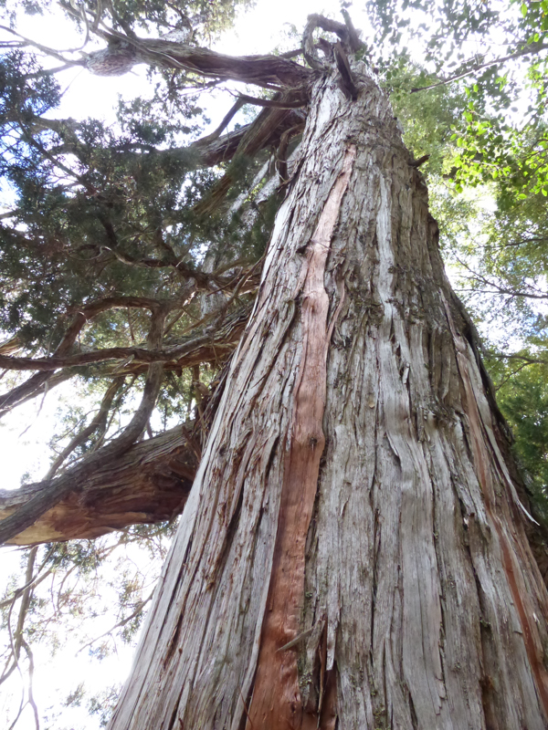
A grand old Alerce tree
Moving on towards our target in Bariloche, we took the scenic route along the edge of the mountains, through the Alerces national park, so called because of the ancient Alerces trees that grow in the park. These are extremely slow and long growing trees (the oldest are several thousand years old), valued for the robustness of the wood, so much so that the wood was used to tile houses in Southern Chile until the trees were protected. There are only a few very old trees within easy reach in the park, but the park itself is beautiful, with stunning scenery, which we could appreciate on the few short walks we took.
As my knees had rather taken a beating on our three day trek to see the Southern ice field in the Glacieres national park, we wanted to make sure we built the walking again, after a few weeks rest (climbing isn’t walking!), gently. So we started with a few short walks in the Alerces park, building up with some longer walks around El Bolson, a little further north.
A tough little day’s hike to the summit of Co. Piltriquitron
We spent several days in and around El Bolson, enjoying a regular craft and food market, some of the best empanadas we’ve had and a range of locally crafted artisanal beers, as well as, of course, doing some “training” walks. One was a tough little day’s trek from a car park at the end of a steep dirt track (where we had spent the night) at 1,200m to the 2,250m summit of the major peak next to the town, Co. Piltriquitron. Unfortunately, as we neared the summit, the cloud came in and we couldn’t see a thing, so we chose to see it as a good training exercise. And, as it turns out, the steep, scree slopes on this were indeed a taster of things to come! The next walk we did was into a refugio next to a dramatic little canyon, with much less height gain, but with more distance.


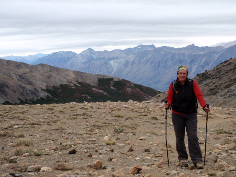
Argentinian treat 4: The Cerro Catedral range and Bariloche
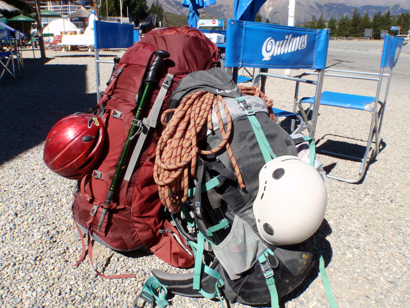
Remarkably, we managed to get climbing gear, camping gear and some food supplies into these packs!
Now there was nothing between us and Cerro Catedral, the dramatic mountain range overlooking the city of Bariloche. Our first trip into the range was for rock climbing and despite my concerns about carrying climbing kit, tent and some food supplies (although we ate dinner served by the refugio each night) the 9km and 700m up to Refugio Frey, which would be our base, but, after leaving the van in a secure car park in town and getting a bus to the trail head, we took the walk steadily and arrived in the beautiful valley just as the sun was going down. We pitched our tent behind one of the stone wall shelters near the refugio and settled in for our first refugio experience.

Bruce considers possible climbing routes, with the Frey valley stretched out far below him
The climbing around Frey was spectacular, with the refugio being set at the entrance to a dramatic bowl of rock, with the cathedral spires-like peak of Cerro Catedral looking down on us at the opposite end. We had an exhausting but thoroughly enjoyable and exciting few days exploring the area, but managed to do surprisingly little real climbing, despite the glorious sunny weather and clear skies. Outside of the areas right opposite the refugio, route finding was challenging. We spent one day looking for a guidebook promised easier line on the very far side of the bowl, taking in several 100m of scramble up scree, emerging to an amazing view over into the next valley, but didn’t manage to find the targeted section of rock at all! But we did have a condor sweep passed us so close that we heard the whistle of the wind as it passed before we saw it sweeping away in the distance – just that alone would have made that days venture worthwhile, even though we didn’t actually climb at all that day!
We concluded that it is perhaps the sort of destination that you need to spend a few days, either on a first visit, or the first part of a longer visit, getting your bearings, adjusting to the intimidation of the surroundings and generally acclimatising, before the best of the climbing will be possible. That and, perhaps, you need to be climbing at a higher level that, certainly, I (Rebecca) am!!

Our little “casita”, which came complete with local dogs
On our second night at the Refugio, a Saturday, we found ourselves sat next to a family from the US, who had made the rather impressive trek around the ridge into the valley with two young, but very game, kids. We played Uno with the kids, shared our biscuits and several bottles of red wine (with the parents) over a very pleasant evening, which ended with them inviting us to come stay with them when we went back down. The lovely Nachman family are renting a house on the lake for a year that happens to come with an outhouse (serving as an office for Andy, a digital nomad for a year) and a “casita” (little house) guesthouse, where we stayed for a week or so. Wonderful!
After a couple of day’s back down out of the mountains (for some washing and general wind-down and recovery time), it was time to get back into the mountains to do the planned multi-day trek before the weather broke, which was expected the following weekend.

Setting out on the Nahuel Huapi traverse from the refugio at the top of the ski-lift
The trek we wanted to do is known as the Nahuel Huapi traverse and joins each of the Refugios in the immediate Co. Catedral range. The first stage takes you to Refugio Frey, either following the walk up the valley in that we had done a few days earlier or by taking a ski-lift up the mountain and following a dramatic ridge walk around (the route the Nachman family had taken). Our second time up, we took the ski-lift up and followed the ridge then, having been to Refugio Frey before, carried on directly to the next refugio at Lago Jakob – a long but spectacular and satisfying day’s walk, rounded off by a quiet night sleeping in the refugio, with just a few others, and a fondue for supper!

The dramatic traverse up and over between the refugios
The second day (day 3 of the full route) was to be the most challenging, involving full on scrambling steeply up the hill behind the refugio to access the ridge, then careful navigation around the edge to drop down into the valley below the next refugio at Laguna Negro. We joined up with a British backpacker, Matt, whose walking companion was heading back out of the range that day and received a full briefing, with photos, from the refugio staff after breakfast before setting off. And what a day it turned out to be! The climb up was great fun, revealing stunning vistas of the full mountain range at the top, with Mount Tronadore (the highest peak) in the near distance and Chilean volcanoes in the far distance.

The descent route, straight down this gully at the head of the valley, 800m of continuous descent
Having navigated around to the correct point to drop down into the valley correctly, we couldn’t quite believe what awaited us – we had had quite a bit of steep scrambing and sliding down scree slopes already on this trip, but this descent was 800m of what felt at times like we were almost going straight down! And it didn’t stop when we got down to the tree filled valley bottom, as we weaved our way between the trees, along the stream and onwards down even further to get to they very bottom. It was actually a relief when we had a clear, well built, switch back path to follow to climb back up 300m to get up to the refugio for the night! That last climb up was the first time that whole day that we had simply walked, ie not having to carefully place each foot with each step, for more than about 100m. Exhausting – but a fantastic adventure!
That night was a Friday, the last weekend, as it turned out, of the summer, and the Refugio was heaving, with hoards of teenagers and walkers around it as we arrived surrounded by a beautiful sunset. We hastily found a quiet spot to pitch our tent, in a hurry to find some space to sit in the refugio to have dinner! We took the easy, but long (18km) walk out along the valley the next day, allowing us to walk all the way back to the Nachman’s place, where the van was waiting for us parked next to our lovely little casita.
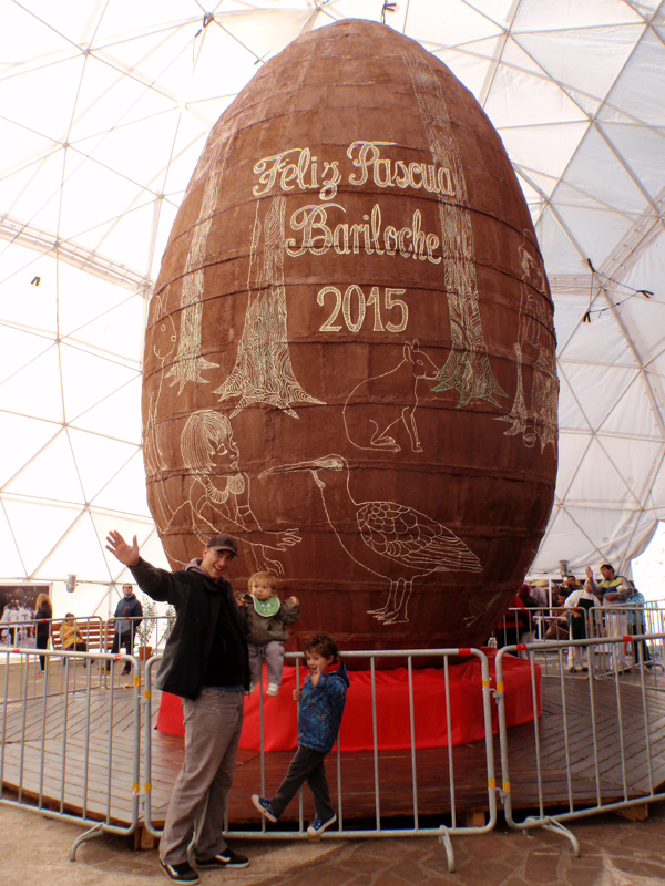
Each year, the chocolate makers of Bariloche team up to make the world’s largest Easter Egg for the annual chocolate festival
In the end, we got our mountain adventures in just before the weather broke. It was the day following our walk out that it felt like autumn had arrived, the sun was hidden by clouds and the temperature dropped considerably. We stayed in Bariloche for another few days, rewarding ourselves with more meals of fabulous steak, testing more of the various artisanal beers, helping our host, Andy, celebrate his 40th birthday, and waiting to see something of the annual chocolate festival in Bariloche before we left.
From Bariloche, we took a few days to explore more of the Argentinian lakes region, driving up to San Martin de los Andes and back, and enjoying a lovely forest of the delightful, orange Arrayanes trees, before heading back west to cross the border and pass through to the mountains into Chile again and pick up where we left off on our journey through southern Chile.


Pingback: The winding road to Santiago – part 2: Southern Chile | Yellow Van Days